Practical examples of embracing new principles, deciding on new or revised strategic goals, and planning new actions to achieve them can help adaptation seem tractable and achievable, despite the fact that adaptation planning for biodiversity may look very different when compared with traditional approaches to planning of assets, managing or eliminating threats, or even managing resilience of systems as they are today.
The New principles and approaches section suggested a new approach to biodiversity planning and the The Biodiversity Adaptation Toolbox provided guidance on implementing these new ideas.
To explore examples of these new approaches in action, and to see how the measures presented in this Module might be used to inform this process, click on the topics below.
-
 Integrating new principles into resilience planning in the Goulburn Broken
The Goulburn Broken Catchment Management Authority (GBCMA) in Victoria is commencing an update of its Biodiversity Strategy, so this is an ideal time to consider how the CMA might begin incorporating new principles for biodiversity conservation under climate change. The precise way they do this will depend on diverse input, stakeholder engagement, and resources available, but initial conversations with Kate Brunt and Carla Miles of GBCMA suggest the following possibility:
As the GBCMA has a Regional Catchment Strategy (RCS) currently in place until 2019, it makes sense to consider which of the potential new principles are most reflected already in the language and approaches used in the RCS and the existing Biodiversity Strategy. The RCS was developed using a resilience planning approach with a focus on system dynamics and tipping points. There is an emphasis on ecological processes in both documents, suggesting that the CMA have in essence already adopted the principle ‘Optimise ecological processes’ – particularly the strategic goal of ‘Help nature take its course’ through strategic initiatives and actions like biolinks (connectivity) projects and supporting local/ landscape-scale implementation plans.
The CMA also divided their catchment into social-ecological systems (SES) where different land uses, ecosystems, and histories of human engagement mean that different assets are valued. This suggests that regional character (even sub-regional character) is valued, and thus the principle of ‘Maintain regional character’ already has a foundation in the Goulburn Broken. Finally, both the RCS and the existing Biodiversity Strategy focus on capturing opportunities for biodiversity associated with land use change for other reasons, revealing that the building blocks to adopt the principle ‘Promote cross-sectoral adaptation planning’ are already in place.
These three new principles (Optimise ecological processes, Maintain regional character, and ‘Promote cross-sectoral adaptation planning’ could then be incorporated into a revised vision statement for the GBCMA’s Biodiversity Strategy. The current vision focuses on healthy ecosystems and viable populations. But one that acknowledges the pressure to change under climate change and embraces new principles could read something like this: ‘Ecosystems and landscapes that may change over time but where key processes, services and values are maintained. Also, our region and its sub-catchments maintain a unique sense of identity, and land uses change to adapt to global pressures without harming the capacity of biodiversity to similarly adapt and change.’
Some existing strategic goals in the GBCMA’s Biodiversity Strategy (‘outcomes’) and implementation approaches (‘strategic initiatives’) align with this vision and could continue under a more climate-adapted strategy. But one key goal to consider explicitly introducing may be ‘Maintain key services’. Aligned with a systems planning approach with a focus on tipping points, the GBCMA could identify the services or values most important in the catchment and then undertake an adaptation pathways planning process to identify tipping points beyond which those values or services would be lost (see The NRM Adaptation Checklist for more on adaptation pathways).
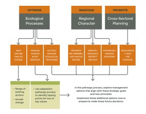
Applying new principles and potential strategic goals into resilience planning in the Goulburn Broken
The GBCMA is in fact currently implementing an Adaptation Pathways planning process in one SES. The Biodiversity Strategy update could apply learnings from this process to explore alternative strategic goals and implementation options beyond those tipping points across the whole region. The possibilities to consider would be drawn from the set of goals and implementation options that are aligned with the new principles they choose to adopt. Focusing on the vision and new principles thus helps to readily identify a suite of options to consider and can ensure consistency across all the different services/values, thus further minimising the risk of mal-adaptation. The figure on the left thus illustrates what the set of new principles and potential strategic goals might look like for GBCMA. Click on the image to view it in full size. It is a subset of The Biodiversity Adaptation Toolbox, showing how new principles, goals and actions could be tailored to each region’s preferred approach. For GBCMA, it shows the new principles highlighted above, along with the implementation approaches that would be used now, with others planned for the future through the pathways process.
-
Managing and restoring connectivity to optimise multiple processes
Managing and restoring ecological connectivity is possibly the most frequently adopted approach for biodiversity adaptation under climate change to date. However, confusion can arise because there are often many different analyses and recommendations. Recognising the way these are aligned to different strategic goals and ultimately the new principles for biodiversity can help reduce the confusion and make the most of connectivity initiatives.
For example, Jason MacKenzie from the ACT Environment and Planning Directorate (ACT EPD) has three different connectivity analyses to draw on for the region. But each of them addresses a different ecological process that depends on landscape connectivity and could help nature respond naturally to climate-driven environmental change. All three could be used in concert to achieve the goal of ‘Help nature take its course’ under the principle of ‘Optimise ecological processes’.
1. Connectivity to support adaptive processes of large populations: Traditionally, fine-scale connectivity has been restored to facilitate dispersal in fragmented landscapes and allow multiple smaller populations to function as one larger population (a meta-population). Larger populations have greater genetic, phenotypic, and behavioural diversity, suggesting larger populations also have greater capacity to respond and adapt to climate change. Thus, fine-scale, local connectivity can also be used to foster the natural adaptive capacity of species through creating larger functional populations. ACT EPD has a fine-scale model (Barrett & Love, 2012) showing where connectivity is likely to exist (and thus require protection) and not exist (and thus require replanting) based on a synthesis of empirical research on connectivity for woodland and forest birds and mammals (Doerr et al., 2010).
2. Connectivity to support migration processes: Multiple migratory birds often share the same migratory pathways. Thus, even though the actual species migrating may change over time under climate change, management to support general migratory pathways can help ensure the key process of migration continues. An analysis by Birds Australia suggests that the ACT is part of a key flyway for migratory woodland and forest birds in southeast Australia so maintaining stop-over habitat in the ACT could contribute to migratory connectivity, even under climate change.
3. Connectivity to support range shifts: Connectivity for climate change is often only considered in the context of supporting dispersal movements that will allow species to shift their ranges to new areas of suitable habitat. An analysis of potential paths connecting similar ecological environments between current and future time periods (Drielsma et al., 2014) shows that the southern part of the ACT will serve a critical role in providing this type of climate change corridor. It also shows that links eastward through the north of the ACT and then northward into NSW may serve as pathways for potential range shifts.
Putting them together in one ‘connectivity strategy’: ACT EPD can use connectivity management and restoration as a way to support all of these processes at once, often in the same places. By building fine-scale connectivity to connect woodland and forest remnants, but doing so particularly east-west across the north of the ACT and extending northward into the ‘Greater Goorooyarroo’ area in NSW, larger populations and range shifts are likely to be supported. Ensuring that some larger habitat areas are part of these ‘corridors’ also provides for migration stop-over points for woodland birds.
-
A decision point triggers actions to maintain key services on the Monaro Tablelands
In areas where effects of climate change are expected to be pronounced, decision points can be established to guide when adaptation interventions need to be considered. Principles for biodiversity conservation under climate change can then be used to guide which (or whether) actions will be taken.
The Monaro region on the NSW Southern Tablelands supports extensive areas of grassland interspersed with mosaics of mature Eucalyptus viminalis trees. These trees are important to graziers for stock shelter and shape the distinctive scenery of the region – key services that are valued by residents of the Monaro.
In recent years many of the mature trees have begun to die. The deaths have been linked to an outbreak of the eucalyptus weevil (Gonipterus sp.), but the ultimate cause of the weevil outbreaks and hence the dieback is not known. The region’s climate has undergone warming and drying over several decades and Eucalyptus viminalis is also at the fringe of its range in the harsh Monaro climate. It is thought that recent changes in climate are pushing the species beyond a critical threshold.
The widespread deaths of Eucalyptus viminalis provide evidence that key services are being lost, triggering a decision point for local Landcare groups to explore whether and how more intensive management should occur.
A range of potential futures need to be considered and decisions made regarding on-ground actions. Decisions can be guided by the new principles suggested in this section, as illustrated in the following steps already being considered by local communities:
1. ‘Optimise ecological processes’: Rather than accepting a transition to grassland, with consequent loss of fauna habitat, stock shelter and scenic values, dieback areas could be replanted with other species that are likely to provide similar services. Dead trees are best retained as interim habitat, and planting a diversity of species will optimise likelihood of success in an uncertain future.
2. ‘Maintain the evolutionary character of the Australian biota’: Under this principle, replanting would avoid the alien tree Pinus radiata, which is widely used as a wind shelter on the Monaro already, in favour of other species of Australian Eucalyptus.
3. ‘Maintain unique regional character’: Under this principle, replanting would focus on eucalypts from as close by as possible, including variants of E. viminalis that are estimated to have the potential to persist in current and projected future climates.
Reflecting on the principles underlying the replanting options can provide greater clarity about the choices and help to ensure consistency with other adaptation actions in the region. A clear monitoring approach is also needed for adaptive learning over time.
Drawn from Ross (2013)
A typical vista of dead trees in the Monaro; Source: Tim the Yowie Man
-
Managing characteristic processes to maintain evolutionary character
As the species composition of plant communities changes with the climate, it will be possible to influence trajectories of change towards maintaining important values such as the distinctive evolutionary character of the Australian biota. One way to facilitate this is to help maintain the drivers of this evolutionary character, such as aspects of fire regime.
Australia is a fire-prone continent and its flora has adapted to this in different ways. One of the most familiar responses of Australian vegetation to fire is that of ‘fire-resilient’ communities such as most eucalypt forests and native grasslands – these have the ability to bounce back quickly after fire by re-sprouting.
A less-well known but surprisingly common alternative strategy is that of ‘fire-resistance’ – avoiding fire by developing characteristics that make the vegetation difficult to burn. These characteristics can include low flammability leaves and bark (e.g. succulent saltbushes), and sparse or discontinuous distribution of flammable fuels (Prober et al., 2012c)
This strategy is characteristic of iconic Australian communities such as the Mulga (Acacia aneura sens. lat.) woodlands across inland Australia, fire sensitive eucalypt woodlands of the south-west, chenopod shrublands prominent on the Nullarbor, and native pine (Callitris spp.) communities in northern and southern Australia, and creates diversity in fire-prone landscapes. The dominants of these communities are easily killed by fire and typically regenerate slowly from seed. If the fire frequency is too high, these communities transform to fire-resilient communities such as grasslands.
Many of these fire-resistant communities are currently or potentially threatened with invasion by highly flammable alien grasses such as Buffel grass (Cenchrus ciliaris; see Weeds and Climate Change). With increasing summer rain and increasing temperatures in the south especially, such species have the potential to spread widely through characteristically fire-resistant communities, potentially transforming them to highly flammable, fire-resilient grasslands.
Intensive monitoring and management to prevent incursion or spread of Buffel grass from areas where it is not yet present or common, or intensive management to exclude it from valued places, is an option to help maintain the evolutionary character of Australia’s fire-resistant communities, even if the particular species constituting those communities changes with the climate.
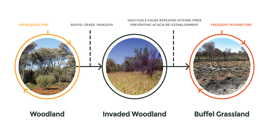
An example of potential transformation of a fire-resistant (Mulga) woodland to a grassland resulting from Buffel grass invasion. Buffel grass
is expected to increase its south- and coast-ward range under climate change. Preventing expansion into new areas could help maintain the diversity of
fire responses in the Australian vegetation. Dotted lines indicate transitions that are difficult to reverse. Source: (left to right): Suzanne Prober; Invasive
weeds, Colin G. Wilson © Colin G. Wilson and the Department of the Environment; Christine Schlesinger. -
Using generalised versus probability projections for vegetation classes
The different ways of presenting projected distribution of vegetation type can provide different types of information to inform planning for vegetation and habitat management.
Generalised (colour) maps show broadly which vegetation class has the highest modelled probability, at baseline or under a specified climate scenario. For Banksia woodlands, comparing the generalised maps (panel (a) and panel (b) in the figure below) tells us that environments throughout much of its current distribution will favour shrubland under the high emissions’ mild MIROC5 climate scenario. We also see that there are only scattered locations between Bunbury and Perth where Banksia woodlands have higher modelled probability than other vegetation types by 2050.
Probability (greyscale) maps of individual vegetation classes on the other hand, do not show which vegetation classes have highest probabilities. Rather, they provide a clearer view of potential pressures and opportunities for each vegetation class to persist. Importantly, while few areas of high suitability (dark grey to black) are projected for Banksia woodlands in 2050, areas of potential moderate suitability do remain throughout the current distribution and elsewhere (panels (c) and (d) in the figure below). Not considering probability maps could risk giving up too soon on existing Banksia woodlands where generalised maps project alternative vegetation classes.
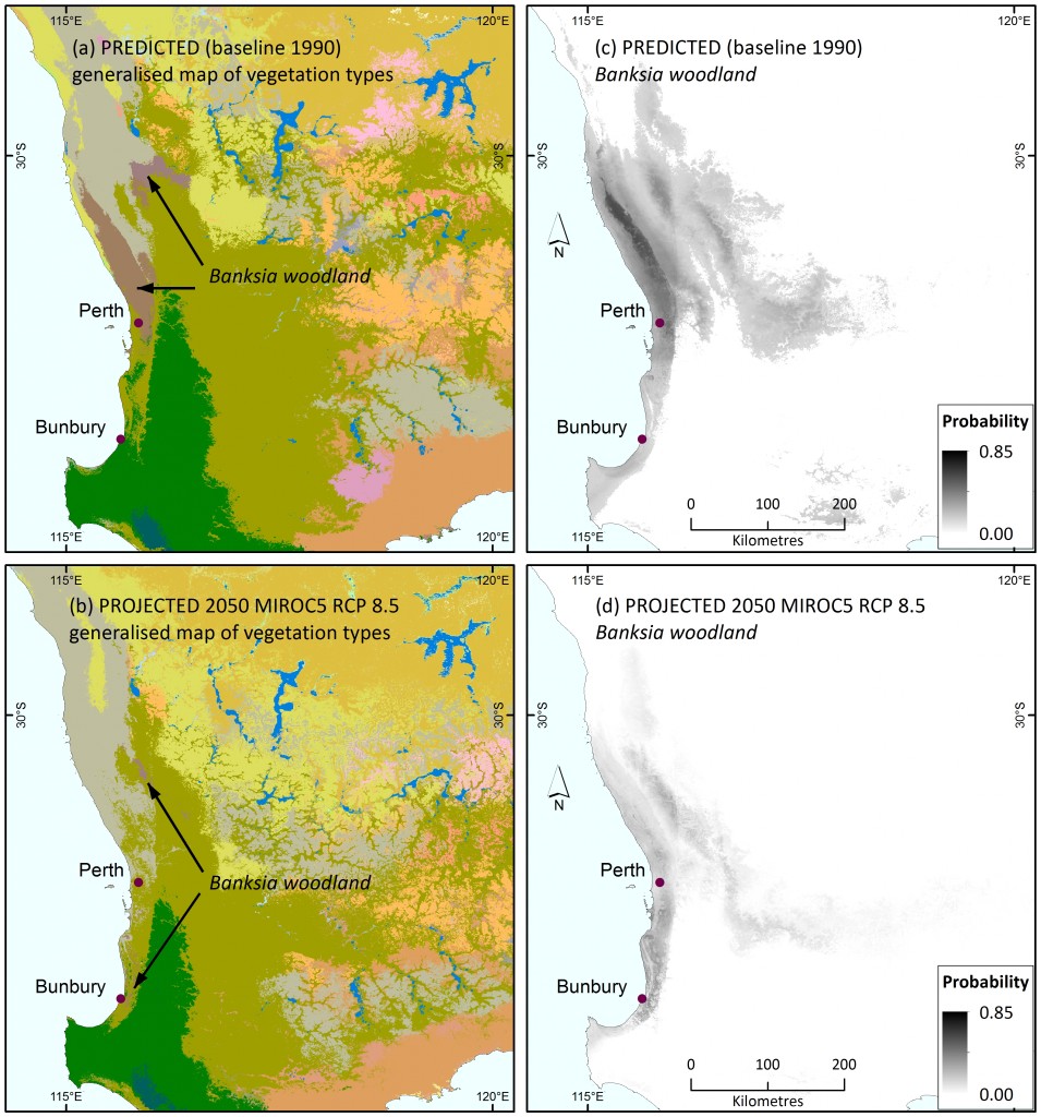
Colour maps show generalised mapping of predicted major vegetation subgroups for baseline climates in south-western Australia (a), and projected under the 2050 mild MIROC5 climate scenario (b). See Figure 2 for legend to vegetation classes; Banksia woodlands are pinkish-brown. Grey scale maps show the predicted probability of Banksia woodland occurrence for baseline (1990) climates (c), and projected under the 2050 mild MIROC5 climate scenario (d).
Taking this information together, planners and managers can weigh up options between supporting persistence of Banksia woodlands species in situ, or facilitating their transition to locations likely to have more suitable environments in the near future.
First, using the probability projection, planners might seek the areas with highest probability for conserving the community in situ, regardless of whether other vegetation classes might be more suitable.
Second, using the generalised map, planners could infer that a projected change from Banksia woodlands to shrubland environments suggests the overstorey Banksias may not persist. Banksia woodlands support a high diversity of plant species in the shrub layer so a diverse shrub layer might still be retained in situ.
However, the Banksia trees themselves support animals such as black cockatoos which feed on Banksia cones and other woody fruits. Priority might therefore focus on Banksia-dependent species for more costly relocation or habitat augmentation options.
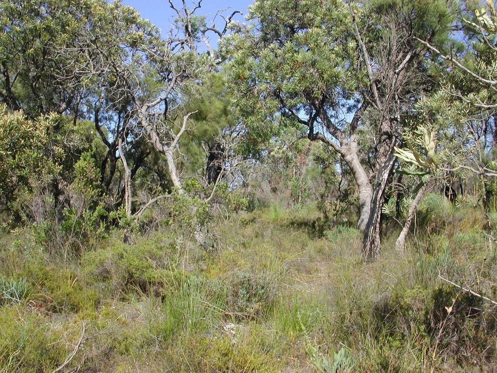
Banksia woodlands are an iconic ecological community of the Perth region. Source: Suzanne Prober
-
Shifts in Cool temperate rainforest in Corangamite CMA
The Corangamite Catchment Management Authority region in Victoria currently contains remnants of Cool temperate rainforest that is unique to the region, stretching southwest from Lorne through Great Otway National Park (see (a) in the figure below). These remnants have high value, not just for biodiversity but also for tourism and a sense of regional character. However, the projected distribution of vegetation type results for this NVIS sub-group (see (b) and (c) in the figure below) suggest that cool temperate rainforest is likely to become even more restricted by 2050 and would virtually disappear from the region based on the high emissions’ hot CanESM2 climate scenario.
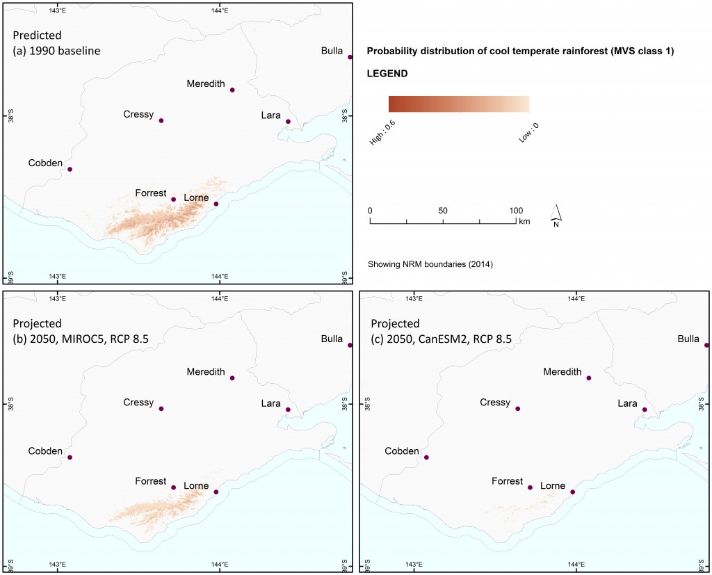
Predicted probability of cool temperate rainforest occurrence for the baseline (1990) climate (a) and projected occurrence for 2050 under the high emissions’ mild MIROC5 (b) and hot CanESM2 (c) climate scenarios.
A variety of ecological similarity measures and additional information can be used collectively to give a more complete picture of what this change could entail. The colour (generalised) maps of vegetation types into the future (see main text) suggest that Eucalypt forest may dominate, with either a tree-fern or a grassy understory. But they also suggest that, particularly under the hot CanESM2 climate scenario, the new vegetation type will continue to be unique in the region, showing stronger affinities with parts of eastern Victoria than the rest of the Corangamite region.
Exploration of the measures introduced in Implications of Climate Change for Biodiversity for vascular plants also show that the overall potential degree of ecological change in the region is not exceptionally high, that these environments are not likely to disappear from a continental perspective, and that the environments that exist in the future will not necessarily be novel. While Cool temperate rainforest may be lost from the region, this may be accomplished through change in a moderate subset of the species present. Although the newly assembling vegetation type may not be unique from a continental perspective, it may still retain a unique character within the region.
Local expert opinion and other sources of information can be used to refine and further explore these interpretations. For example, in an expert workshop hosted by Chris Pitfield of Corangamite CMA, Prof. Peter Gell from Federation University suggested that changes to fire regimes in surrounding vegetation may have the greatest impact on cool temperate rainforest. Combining these insights with the community-level measures, fire regime changes could influence whether or not a tree-fern or a grassy understory comes to dominate and/or may act to accelerate the changes to cool temperate rainforest projected by the analyses.
The options available to the CMA and its stakeholders to manage this change will also depend on the New principles and approaches for biodiversity conservation that they may choose to adopt. For example:
‘Optimise ecological processes’ – If this is a core principle, one goal could be to help nature take its course by minimising other stressors and maintaining connectivity into the areas that currently support cool temperate rainforest.
‘Maintain unique regional character’ – If this is a core principle, analyses suggest these areas are likely to retain unique regional values so one goal could simply be to promote the assembly of the new vegetation type with native species, focusing on monitoring and management of potential transformer species that might threaten that unique character.
‘Promote cross-sectoral adaptation planning’ – If this is a core principle, one goal could be to ensure that any changes to adjacent land uses do not further contribute to changed fire regimes that may accelerate loss of cool temperate rainforest.
-
Revegetation for multiple benefits in Tasmania
Revegetation is usually conducted with multiple aims in mind, so our revegetation benefit measure will almost always need to be combined with other information to guide priorities for placement of revegetation in the landscape. At the moment, most prioritisations incorporate some measure of current biodiversity benefits. Our measure of revegetation benefit estimates benefits for biodiversity of the baseline climate (1990) under future climate scenarios. This could substitute for current benefit layers to explore how priority areas might shift. Because revegetated areas will take decades to mature and begin to provide the full biodiversity benefits intended, prioritising areas that will continue to benefit biodiversity into the future is particularly critical.
For example, the NRM regions in Tasmania (NRM North, NRM South and Cradle Coast NRM) have collaborated to produce a multi-criteria analysis of where revegetation might best serve multiple purposes within the state. They considered carbon sequestration, soil protection and amelioration, and current biodiversity benefits in their analysis, as well as areas where the greatest opportunities may exist due to minimal agricultural use. To include biodiversity benefits, they used an analysis of biodiversity hotspots produced by the Tasmanian Resource Management Council (TRMC). Specifically, the spatial layer was a single metric that summed ratings according to eight criteria:
- Biogeographic distinctiveness
- Distinctiveness of areas of threatened and uncommon plants
- Conservation and reservation status of vegetation communities
- Native vegetation in bioregions with <10% in the reserve system
- Fire and disease refugia
- Glacial refugia
- Important bird habitat
- Freshwater ecosystems
Note that the first two of these criteria place importance on areas that are currently distinctive, particularly in terms of plants, as these areas may disproportionally contribute to state or national scale biodiversity. Our revegetation benefit measure is based on the same principle but under climate change – revegetating areas that will be rare and distinctive in the future to best support the full range of national diversity in the long term. To adjust the existing Tasmanian analysis to plan for future biodiversity benefits, the TRMC biodiversity metric could be disaggregated and revegetation benefit for vascular plants substituted for the first two criteria. Further, revegetation benefit for mammals, reptiles, and amphibians could be incorporated as measures of future importance for faunal habitat.
As this is only one component of a multi-criteria analysis that incorporates many different spatial layers, it would be reasonable to think that updating the existing analysis with these new revegetation benefit layers might not yield very different results. However, an exploration of the layers along with an understanding of how the multi-criteria results will generally be used suggests that adding future revegetation benefit could make a small but significant difference.
The original Tasmanian analysis identified limited opportunities for revegetation – riparian buffers in the northwest and a few more substantial areas in the midlands around the margins of irrigation pivots. But our analysis of revegetation benefit for vascular plants, shown below under the high emissions’ mild MIROC climate scenario, suggests that some of the best opportunities for biodiversity benefits in the future exist along most of the north coast. These areas are more important in the future than at present (panel (c) below), and the existing Tasmanian analysis suggests there are also localised opportunities for change due to patches of minimal agricultural use and potential for carbon benefits and soil improvement as well.
The NRM groups plan to use the analysis to identify focal areas for more detailed regional analysis, including evaluation of potential landholder uptake of revegetation opportunities. The addition of our future revegetation benefit layer in a revised version of the analysis could help identify additional focal areas worthy of further exploration, like the north coast east of Bridport.
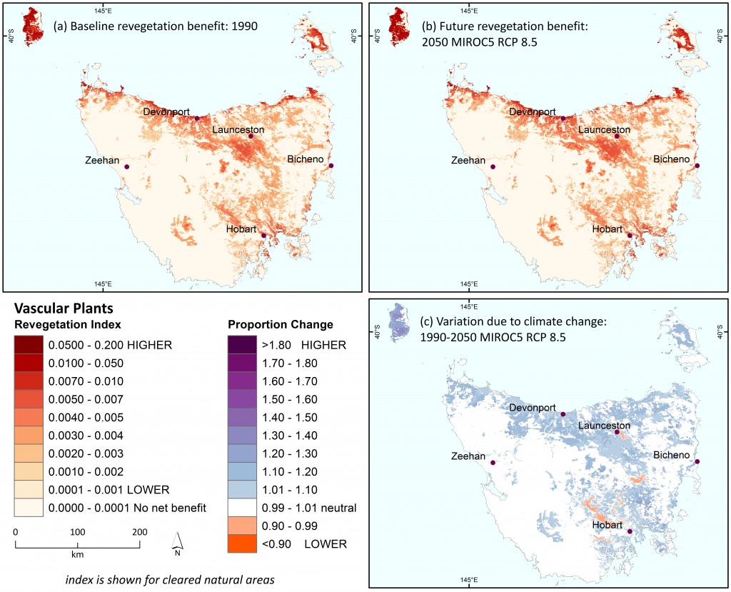
Revegetation benefit for present-day ecological environments for vascular plants in Tasmania (a) under the baseline (1990) climate, (b) for 2050 under the high emissions’ mild MIROC climate scenario, and (c) showing proportional change in accrued benefit under the future climate (calculated as b/a).
Finally, as these multi-criteria analyses are often constructed using means-ends diagrams, it is worth considering New principles and approaches for biodiversity conservation in the context of defining the ‘ends’, and then working backwards to define the means to map/model them. The Tasmanian approach in general and the specific use of revegetation benefit aligns primarily with the potential new principle of minimising species loss nationally, through prioritising ‘distinctiveness’. If additional new principles are adopted, they should be considered as ‘ends’ and might result in different approaches to a revegetation analysis. For example, if new principles adopted include optimising ecological processes and maintaining key services, additional layers representing landscape connectivity to support species’ movements and ecosystem services beyond soil protection could be incorporated. Explicitly recognising the principles underlying the ‘ends’ can lead to greater clarity about the means needed to perform such analyses to actually benefit biodiversity into the future.
-
Integrated use of AdaptNRM information by North West Local Land Services
The approach to new principles for biodiversity conservation and the innovative new measures of impacts and potential adaptation options introduced in the two AdaptNRM biodiversity modules are intended to be viewed as a single set of tools to assist planning and management of our nation’s biodiversity, especially at regional and local scales. While not all users will find all of our measures relevant, thinking of them as a single package can help to reduce ‘information overload’ and ensure they are used in concert, alongside other information, to facilitate the best outcomes.
One example of using the AdaptNRM information as a package, and integrating it with existing biodiversity analyses, comes from North West Local Land Services (NWLLS) in New South Wales. NWLLS are completing a multi-criteria analysis to identify priority areas for biodiversity conservation in their region. This analysis will assign scores for relative biodiversity priority to NWLLS landscapes, based on existing information on biodiversity assets and their values, but not yet incorporating climate change. NWLLS then intend to refine their priority landscapes and the associated actions that might be taken to support them using recently released climate change analyses on biodiversity impacts and adaptation options.
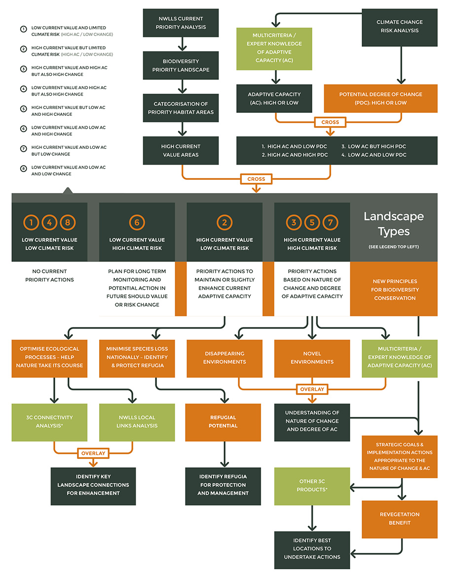
The AdaptNRM team scoped a draft process with NWLLS in a workshop in Canberra on the 15th April 2015, to understand where various products could best be used. While the final approach that will be used by NWLLS in their Biodiversity Prioritisation Plan process may be modified, this case study presents a draft conceptual framework discussed during the workshop. The full draft process is depicted in the following flowchart, in which AdaptNRM products are shown in orange. Click on the image to view it in full size. Its key features include:
- Using the potential degree of ecological change as a combined measure of exposure and sensitivity in a risk analysis
- In that risk analysis, combining a binary layer of potential degree of ecological change with a binary layer of adaptive capacity to produce four risk categories
- Crossing those risk categories with a binary layer of current value (from the existing biodiversity prioritisation analysis) to produce eight landscape types that differ in current biodiversity value, degree of potential ecological change, and existing adaptive capacity – low adaptive capacity and/or high potential change constitute a climate-related risk for areas with high current biodiversity value
- Using those landscape types, combined with consideration of new principles for biodiversity conservation, to identify priority landscapes for three broad approaches – monitoring future change, maintaining adaptive capacity, and engaging in more advanced adaptation planning
- For more advanced adaptation planning (for landscapes with high current value and high climate-related risk), using disappearing ecological environments and novel ecological environments as well as an understanding of adaptive capacity to consider not just the amount of risk but the nature of the risk as well
- Using information on new principles, strategic goals, and potential implementation actions to target actions to the nature of the risk (e.g., where novel ecological environments are likely to arise but adaptive capacity may be low, support the assembly of new communities based on native species using connectivity restoration and assisted dispersal if necessary)
- Planning to implement actions based on spatial analyses of their effectiveness in the future
This process might initially focus on using the AdaptNRM measures for vascular plants, but additional species groups could be included later. It should also be repeated for multiple climate scenarios with final decisions made based on the collective results. It may not be ideal, and other options are certainly possible, but multiple AdaptNRM products can be used alongside other information to create a consistent approach to climate-ready adaptation planning for biodiversity.
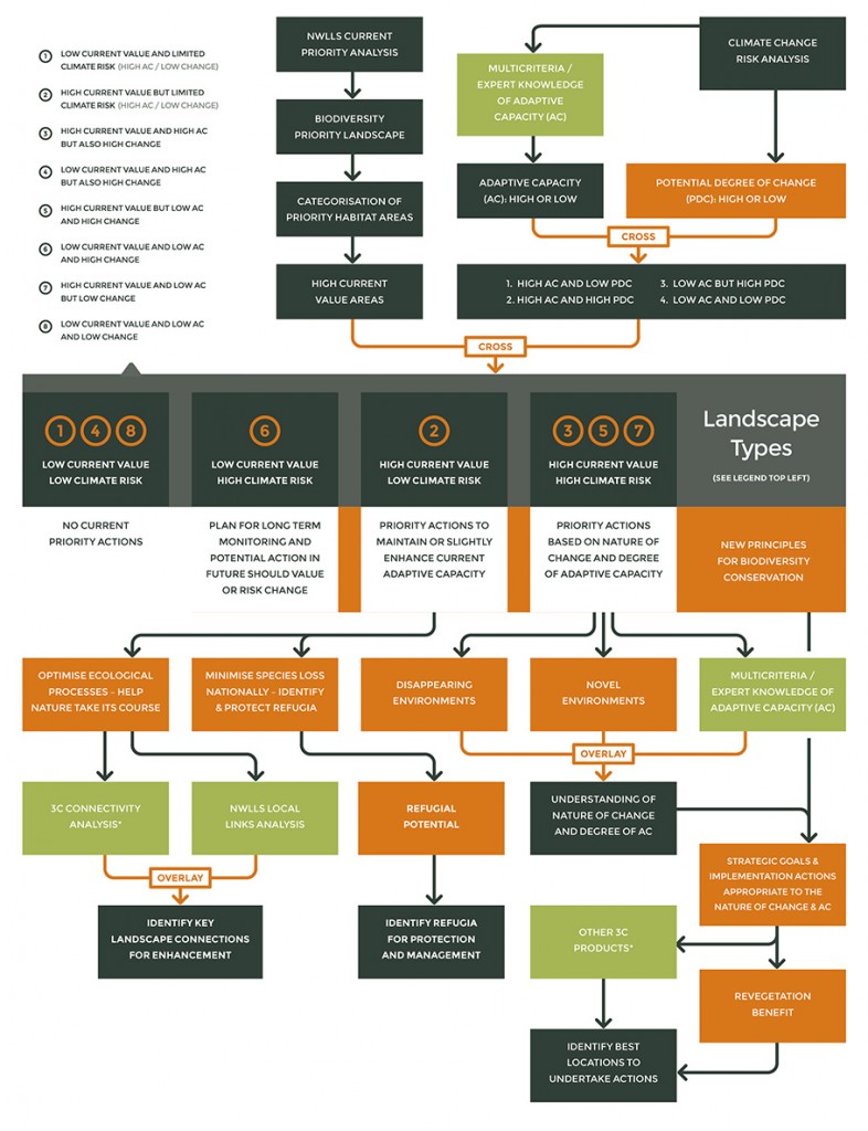
The full draft process used by North West Local Land Services (NWLLS) in their Biodiversity Prioritisation Plan. AdaptNRM products are shown in orange.