Map posters and datasets (suitable for use in GIS) are available for all the measures introduced in this Guide. A higher resolution version of the Guide is also available for direct download. Maps are organised by measure of change and are presented in two parts for the four biological groups. Datasets are national for each measure of change, biological group, and climate scenario. Details of the maps and datasets available are provided in Technical Note 1 in the Guide.
There are several ways to access these resources from the CSIRO Data Access Portal (DAP). Click on the instructions below for details.
Find out more
Open allClose allVisit the landing page for the Guide. From here, you can select the ‘Data’ tab and follow the instructions to download the higher resolution version of the Guide or scroll down to ‘Related Materials’ where links to each of the datasets and a landing page for the maps should appear.
Visit the landing page for the maps. From here, you can select the ‘Data’ tab, open a folder to view all the maps available, and follow the instructions to download. You can also scroll down to ‘Related Materials’ in the ‘Description’ tab to find links to each of the datasets.
Visit the homepage for the CSIRO Data Access Portal (DAP) where you can use the search engine to find a specific resource. Below is a list of search terms we recommend you use.
- ‘adaptnrm’: results in all AdaptNRM products, including Weeds and Climate Change (module 2), Implications for Biodiversity (module 3) and Helping Biodiversity Adapt (module 4) datasets and maps
- ‘adaptnrm biodiversity’: results in all AdaptNRM biodiversity products, including Implications for Biodiversity (this module) and Helping Biodiversity Adapt (module 4)
- ‘adaptnrm biodiversity’ plus any of the measures of change and/or biological groups will limit your search to more specific datasets. For example, entering ‘adaptnrm biodiversity disappearing’ will result in datasets and maps for ‘disappearing ecological environments’ for each of the biological groups and climate scenarios.
Note that while the map posters were designed for appropriate viewing in the A0 format, these are relatively large files (~20-50Mb). So we have produced lower resolution copies of all the map posters that can be more easily downloaded and printed on A3 paper. We suggest that you initially access the smaller A3 size map posters relevant to your region for exploration while reading the Guide. As these are not recommended for planning purposes, you can then decide which A0 map posters you wish to download and use for planning and which datasets (~1Gb in size) you wish to download and work with in GIS.
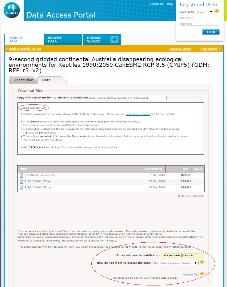
Please note that large collections in the DAP, such as the posters, and the ‘disappearing’ and ‘novel’ datasets are not always immediately available. Notification and instructions for access will appear in DAP for these large collections, as shown in the example below. Follow these instructions and, if required, complete the data request form at the bottom of the page.
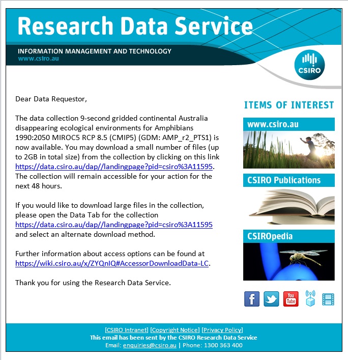
Following your data request, you will receive an email notification once the data has been made available. This can take minutes to some hours depending on the size of the collection. Follow the link to the DAP provided in the email. The requested files will be available for download for a 48 hour period. After this period another request will be needed to access and download files again. An example of the email notification is shown below.
Acknowledgement:
For their roles in producing, coordinating, and making available the CMIP5 model output, we acknowledge the MIROC5 and CAN-ESM2 climate modelling groups, the World Climate Research Programme’s (WCRP) Working Group on Coupled Modelling (WGCM), and the Global Organization for Earth System Science Portals (GO-ESSP).